


Lacs des gardioles

randochu
User
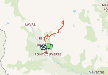

Length
12.4 km

Max alt
2687 m

Uphill gradient
830 m
Km-Effort
23 km

Min alt
1862 m

Downhill gradient
828 m
Boucle
No
Creation date :
2022-08-30 07:03:25.835
Updated on :
2023-03-27 08:53:51.505
6h02
Difficulty : Medium

FREE GPS app for hiking
 SityTrail
IGN / Geographical institutes
SityTrail Plus
The world is yours!
About
Trail Walking of 12.4 km to be discovered at Provence-Alpes-Côte d'Azur, Hautes-Alpes, Névache. This trail is proposed by randochu.
Positioning
Country:
France
Region :
Provence-Alpes-Côte d'Azur
Department/Province :
Hautes-Alpes
Municipality :
Névache
Location:
Unknown
Start:(Dec)
Start:(UTM)
306661 ; 4989691 (32T) N.
Comments