Trail Walking Villard-de-Lans - Sentier Gobert - Photo
 crocau
crocau

User

© OpenStreetMap contributors
Length
Length
7.8 km
Max alt
Max alt
1577 m
Uphill gradient
Uphill gradient
446 m
Km-Effort
Km-Effort  
13.7 km
Min alt
Min alt
1172 m
Downhill gradient
Downhill gradient
445 m
Boucle
Boucle
Yes
Creation date :
2022-09-11 11:57:10.306
Updated on :
2022-09-20 18:34:37.822

(0 Reviews)

Walking
Walking
3h34
Difficulty : Difficult

Scan this QR Code to open this trail in the SityTrail application

FREE GPS app for hiking

Logo SityTrail SityTrail

IGN / Geographical institutes

Download SityTrail from the App Store Download SityTrail from Google Play

Logo SityTrail SityTrail World

The world is yours!

Download SityTrail from the App Store Download SityTrail from Google Play Download SityTrail on Huawei AppGallery

About

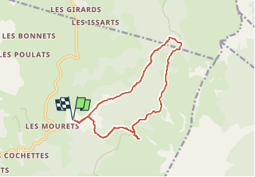
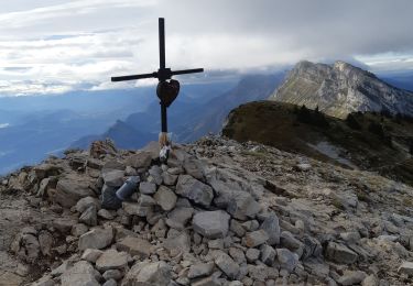
Trail Walking of 7.8 km to be discovered at Auvergne-Rhône-Alpes, Isère, Villard-de-Lans. This trail is proposed by crocau.

Description

Rando facile à moyenne. Dénivelé de presque 500 mètres. Attention, en arrivant à la combe de Chaulange,  il y a un virage en épingle à ne pas louper pour rejoindre le balcon. Par la suite, après le virage de Fond froide,on tombera sur un carrefour rendu imprécis  au milieu des prairies à cause de l'eau qui déborde des abreuvoirs.  Sympa mais il faut rester vigilant.

Elevation profile

Photos

Positioning

Country:
France
Region :
Auvergne-Rhône-Alpes
Department/Province :
Isère
Municipality :
Villard-de-Lans
Location:
Unknown
Start:(UTM)
703022 ; 4994320 (31T) N.

Trails nearby

Trail Snowshoes Lans-en-Vercors - La Crête des Ramées de nuit en raquettes - Photo
Snowshoes
patjobou

Snowshoes

Medium
(1)
Lans-en-Vercors, Auvergne-Rhône-Alpes, Isère, France
8 km | 13.4 km-effort
4h 9min
Yes
Trail Walking Villard-de-Lans - villard col des 2 soeurs - Photo
Walking
arnaudconde

Walking

Medium
(1)
Villard-de-Lans, Auvergne-Rhône-Alpes, Isère, France
7.7 km | 13.8 km-effort
2h 45min
Yes
Trail Walking Lans-en-Vercors - Le Pic saint michel - Photo
Walking
patjobou

Walking

Easy
(1)
Lans-en-Vercors, Auvergne-Rhône-Alpes, Isère, France
6.5 km | 13.2 km-effort
2h 38min
No
Trail Walking Lans-en-Vercors - le vertige des cimes - Photo
Walking
jeanfcd

Walking

Medium
(1)
Lans-en-Vercors, Auvergne-Rhône-Alpes, Isère, France
6.3 km | 11 km-effort
2h 9min
Yes
Trail Walking Villard-de-Lans - cabane de robon - Photo
Walking
Sylvie Mathiot

Walking

Very easy
(1)
Villard-de-Lans, Auvergne-Rhône-Alpes, Isère, France
10.2 km | 15.8 km-effort
5h 25min
Yes
Trail Walking Lans-en-Vercors - 38 pic st michel - Photo
Walking
himba26100

Walking

Easy
(1)
Lans-en-Vercors, Auvergne-Rhône-Alpes, Isère, France
8.7 km | 17.3 km-effort
5h 16min
Yes
Trail Snowshoes Lans-en-Vercors - Le Pic Saint-Michel en raquettes (2012) - Photo
Snowshoes
tracegps

Snowshoes

Medium
(2)
Lans-en-Vercors, Auvergne-Rhône-Alpes, Isère, France
8.4 km | 17.3 km-effort
5h 0min
Yes
Trail Mountain bike Corrençon-en-Vercors - Grande Traversée des PréAlpes à VTT : Corrençon en Vercors - La Chapelle en Vercors - Photo
Mountain bike
tracegps

Mountain bike

Difficult
(1)
Corrençon-en-Vercors, Auvergne-Rhône-Alpes, Isère, France
25 km | 36 km-effort
3h 30min
No
Trail Walking Villard-de-Lans - Le sentier Peronnard et le Pas de l'OEille - Photo
Walking
tracegps

Walking

Easy
(1)
Villard-de-Lans, Auvergne-Rhône-Alpes, Isère, France
13.7 km | 25 km-effort
6h 0min
Yes


Close
My subscriptions