


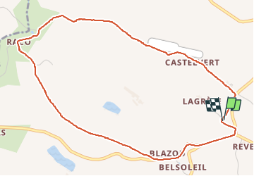
Eglise Saint Sernin sentier des archéologues court

jpipacific
User

Length
5.9 km

Max alt
280 m

Uphill gradient
75 m
Km-Effort
6.9 km

Min alt
217 m

Downhill gradient
77 m
Boucle
Yes
Creation date :
2022-09-12 07:56:21.832
Updated on :
2022-09-12 10:29:09.163
1h15
Difficulty : Easy

FREE GPS app for hiking
 SityTrail
IGN / Geographical institutes
SityTrail Plus
The world is yours!
About
Trail Walking of 5.9 km to be discovered at Occitania, Tarn, Lombers. This trail is proposed by jpipacific.
Description
Randonnée à partir du parking de l'Eglise et cimetière de Saint Sernin.
Cette randonnée emprunte le sentier des archéologues mais ne le suit pas en totalité et coupe par le sentier qui va de la route D4 au Raco.
Positioning
Country:
France
Region :
Occitania
Department/Province :
Tarn
Municipality :
Lombers
Location:
Unknown
Start:(Dec)
Start:(UTM)
429783 ; 4852673 (31T) N.
Comments