


Col de la Schlucht Markstein

Annie Leduc
User
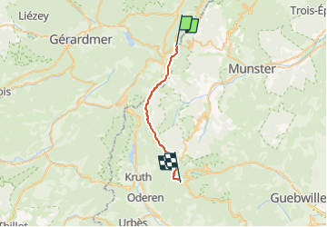

Length
19.6 km

Max alt
1304 m

Uphill gradient
611 m
Km-Effort
28 km

Min alt
1141 m

Downhill gradient
559 m
Boucle
No
Creation date :
2022-09-12 12:29:51.827
Updated on :
2022-09-12 13:13:22.16
6h14
Difficulty : Medium

FREE GPS app for hiking
 SityTrail
IGN / Geographical institutes
SityTrail Plus
The world is yours!
About
Trail On foot of 19.6 km to be discovered at Grand Est, Vosges, Le Valtin. This trail is proposed by Annie Leduc .
Positioning
Country:
France
Region :
Grand Est
Department/Province :
Vosges
Municipality :
Le Valtin
Location:
Unknown
Start:(Dec)
Start:(UTM)
352685 ; 5325302 (32U) N.
Comments