


Lac longemer

jcschubnel
User
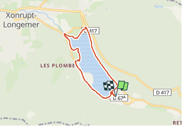

Length
6 km

Max alt
764 m

Uphill gradient
78 m
Km-Effort
7 km

Min alt
731 m

Downhill gradient
78 m
Boucle
Yes
Creation date :
2022-09-12 11:05:10.31
Updated on :
2022-09-12 16:01:15.961
3h37
Difficulty : Medium

FREE GPS app for hiking
 SityTrail
IGN / Geographical institutes
SityTrail Plus
The world is yours!
About
Trail Walking of 6 km to be discovered at Grand Est, Vosges, Xonrupt-Longemer. This trail is proposed by jcschubnel.
Positioning
Country:
France
Region :
Grand Est
Department/Province :
Vosges
Municipality :
Xonrupt-Longemer
Location:
Unknown
Start:(Dec)
Start:(UTM)
347941 ; 5325385 (32U) N.
Comments