


les planes la canourgue

RoMo
User
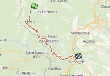

Length
22 km

Max alt
1062 m

Uphill gradient
447 m
Km-Effort
29 km

Min alt
515 m

Downhill gradient
921 m
Boucle
No
Creation date :
2022-09-06 06:14:03.001
Updated on :
2022-09-12 19:41:58.516
6h08
Difficulty : Medium

FREE GPS app for hiking
 SityTrail
IGN / Geographical institutes
SityTrail Plus
The world is yours!
About
Trail Walking of 22 km to be discovered at Occitania, Lozère, Trélans. This trail is proposed by RoMo.
Description
beau paysage
Positioning
Country:
France
Region :
Occitania
Department/Province :
Lozère
Municipality :
Trélans
Location:
Unknown
Start:(Dec)
Start:(UTM)
507730 ; 4929007 (31T) N.
Comments