


SityTrail - SityTrail - 2021-09-16StNom

Rando MLC
User

Length
10.8 km

Max alt
160 m

Uphill gradient
108 m
Km-Effort
12.2 km

Min alt
109 m

Downhill gradient
111 m
Boucle
Yes
Creation date :
2022-09-13 08:38:26.282
Updated on :
2022-09-13 08:40:06.399
2h47
Difficulty : Easy

FREE GPS app for hiking
 SityTrail
IGN / Geographical institutes
SityTrail Plus
The world is yours!
About
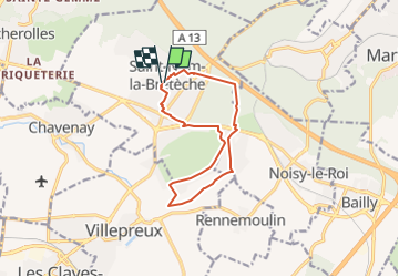
Trail On foot of 10.8 km to be discovered at Ile-de-France, Yvelines, Saint-Nom-la-Bretèche. This trail is proposed by Rando MLC.
Positioning
Country:
France
Region :
Ile-de-France
Department/Province :
Yvelines
Municipality :
Saint-Nom-la-Bretèche
Location:
Unknown
Start:(Dec)
Start:(UTM)
428116 ; 5412620 (31U) N.
Comments