


Beynes

Rando MLC
User
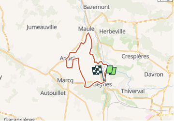

Length
19.7 km

Max alt
131 m

Uphill gradient
214 m
Km-Effort
23 km

Min alt
41 m

Downhill gradient
222 m
Boucle
Yes
Creation date :
2022-09-13 15:36:47.344
Updated on :
2022-09-25 09:55:04.56
4h51
Difficulty : Very difficult

FREE GPS app for hiking
 SityTrail
IGN / Geographical institutes
SityTrail Plus
The world is yours!
About
Trail Walking of 19.7 km to be discovered at Ile-de-France, Yvelines, Beynes. This trail is proposed by Rando MLC.
Positioning
Country:
France
Region :
Ile-de-France
Department/Province :
Yvelines
Municipality :
Beynes
Location:
Unknown
Start:(Dec)
Start:(UTM)
417589 ; 5412333 (31U) N.
Comments