


St Rémi

lm178
User

Length
23 km

Max alt
176 m

Uphill gradient
422 m
Km-Effort
29 km

Min alt
62 m

Downhill gradient
415 m
Boucle
No
Creation date :
2022-09-15 07:52:41.712
Updated on :
2022-09-15 15:22:44.317
5h54
Difficulty : Easy

FREE GPS app for hiking
 SityTrail
IGN / Geographical institutes
SityTrail Plus
The world is yours!
About
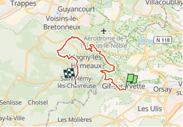
Trail Walking of 23 km to be discovered at Ile-de-France, Essonne, Gif-sur-Yvette. This trail is proposed by lm178.
Positioning
Country:
France
Region :
Ile-de-France
Department/Province :
Essonne
Municipality :
Gif-sur-Yvette
Location:
Unknown
Start:(Dec)
Start:(UTM)
436486 ; 5394289 (31U) N.
Comments