


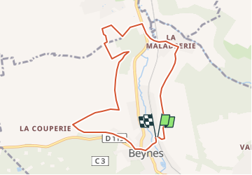
SityTrail - 2022-09-29 Beynes Andelu 1

Rando MLC
User

Length
8.4 km

Max alt
117 m

Uphill gradient
167 m
Km-Effort
10.6 km

Min alt
41 m

Downhill gradient
174 m
Boucle
Yes
Creation date :
2022-09-16 11:18:29.132
Updated on :
2022-09-25 10:07:30.884
2h26
Difficulty : Medium

FREE GPS app for hiking
 SityTrail
IGN / Geographical institutes
SityTrail Plus
The world is yours!
About
Trail Walking of 8.4 km to be discovered at Ile-de-France, Yvelines, Beynes. This trail is proposed by Rando MLC.
Positioning
Country:
France
Region :
Ile-de-France
Department/Province :
Yvelines
Municipality :
Beynes
Location:
Unknown
Start:(Dec)
Start:(UTM)
417589 ; 5412333 (31U) N.
Comments