


Les Terres Rouges

pb07
User
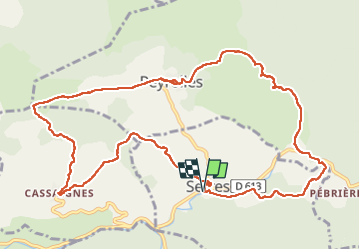

Length
14 km
Boucle
Yes
Creation date :
2022-09-16 08:06:53.613
Updated on :
2022-09-16 13:33:01.925
4h46
Difficulty : Very difficult

FREE GPS app for hiking
 SityTrail
IGN / Geographical institutes
SityTrail Plus
The world is yours!
About
Trail Walking of 14 km to be discovered at Occitania, Aude, Serres. This trail is proposed by pb07.
Positioning
Country:
France
Region :
Occitania
Department/Province :
Aude
Municipality :
Serres
Location:
Unknown
Start:(Dec)
Start:(UTM)
444769 ; 4755035 (31T) N.
Comments