


Forêt de Roumare -Quevillon

JMCMoreau
User
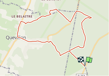

Length
11.1 km

Max alt
134 m

Uphill gradient
215 m
Km-Effort
14 km

Min alt
5 m

Downhill gradient
214 m
Boucle
Yes
Creation date :
2022-09-17 15:35:58.836
Updated on :
2022-09-17 15:41:28.45
3h30
Difficulty : Easy

FREE GPS app for hiking
 SityTrail
IGN / Geographical institutes
SityTrail Plus
The world is yours!
About
Trail Walking of 11.1 km to be discovered at Normandy, Seine-Maritime, Val-de-la-Haye. This trail is proposed by JMCMoreau.
Positioning
Country:
France
Region :
Normandy
Department/Province :
Seine-Maritime
Municipality :
Val-de-la-Haye
Location:
Unknown
Start:(Dec)
Start:(UTM)
354308 ; 5474831 (31U) N.
Comments