


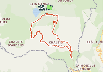
Lac des Plagnes - Chalets de Lens - Refuge des Tinderets

i20
User

Length
9.5 km

Max alt
1694 m

Uphill gradient
577 m
Km-Effort
17.2 km

Min alt
1253 m

Downhill gradient
578 m
Boucle
Yes
Creation date :
2022-09-12 09:07:00.018
Updated on :
2022-09-17 15:44:42.311
2h39
Difficulty : Medium

FREE GPS app for hiking
 SityTrail
IGN / Geographical institutes
SityTrail Plus
The world is yours!
About
Trail Walking of 9.5 km to be discovered at Auvergne-Rhône-Alpes, Upper Savoy, Abondance. This trail is proposed by i20.
Positioning
Country:
France
Region :
Auvergne-Rhône-Alpes
Department/Province :
Upper Savoy
Municipality :
Abondance
Location:
Unknown
Start:(Dec)
Start:(UTM)
327128 ; 5123705 (32T) N.
Comments