


tregunc1

xcreator
User
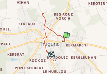

Length
2.4 km

Max alt
46 m

Uphill gradient
18 m
Km-Effort
2.7 km

Min alt
30 m

Downhill gradient
24 m
Boucle
No
Creation date :
2022-09-17 16:07:02.858
Updated on :
2022-09-17 19:10:06.028
2h59
Difficulty : Easy

FREE GPS app for hiking
 SityTrail
IGN / Geographical institutes
SityTrail Plus
The world is yours!
About
Trail Walking of 2.4 km to be discovered at Brittany, Finistère, Trégunc. This trail is proposed by xcreator.
Positioning
Country:
France
Region :
Brittany
Department/Province :
Finistère
Municipality :
Trégunc
Location:
Unknown
Start:(Dec)
Start:(UTM)
436598 ; 5300523 (30T) N.
Comments