


les mazures les vielles forges

trusgnachjf
User
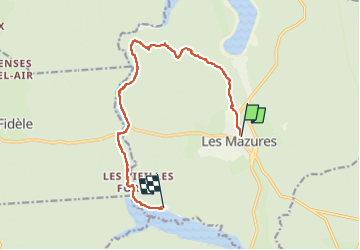

Length
11.9 km

Max alt
389 m

Uphill gradient
166 m
Km-Effort
14.4 km

Min alt
211 m

Downhill gradient
251 m
Boucle
No
Creation date :
2022-09-18 07:05:07.866
Updated on :
2022-09-18 12:53:21.931
5h46
Difficulty : Difficult

FREE GPS app for hiking
 SityTrail
IGN / Geographical institutes
SityTrail Plus
The world is yours!
About
Trail Walking of 11.9 km to be discovered at Grand Est, Ardennes, Les Mazures. This trail is proposed by trusgnachjf.
Positioning
Country:
France
Region :
Grand Est
Department/Province :
Ardennes
Municipality :
Les Mazures
Location:
Unknown
Start:(Dec)
Start:(UTM)
616854 ; 5527559 (31U) N.
Comments