


Ancerville 11 km BS

bstebe
User
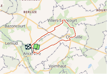

Length
10.9 km

Max alt
307 m

Uphill gradient
141 m
Km-Effort
12.8 km

Min alt
219 m

Downhill gradient
141 m
Boucle
Yes
Creation date :
2022-09-18 15:14:22.772
Updated on :
2022-09-18 15:18:34.847
2h54
Difficulty : Difficult

FREE GPS app for hiking
 SityTrail
IGN / Geographical institutes
SityTrail Plus
The world is yours!
About
Trail Walking of 10.9 km to be discovered at Grand Est, Moselle, Ancerville. This trail is proposed by bstebe.
Description
Départ Eglise d'Ancerville. Boucle contrastée de taille moyenne alternant parcours en fond de vallée le long de ruisseaux et vastes panoramas depuis les coteaux Grosses côtes et Haut de la Laume
Positioning
Country:
France
Region :
Grand Est
Department/Province :
Moselle
Municipality :
Ancerville
Location:
Unknown
Start:(Dec)
Start:(UTM)
309121 ; 5434143 (32U) N.
Comments