


Charly-Millery-Charly par bords Rhône.

dan69390
User
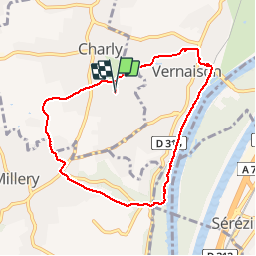

Length
7.9 km

Max alt
298 m

Uphill gradient
160 m
Km-Effort
10 km

Min alt
157 m

Downhill gradient
160 m
Boucle
Yes
Creation date :
2014-12-10 00:00:00.0
Updated on :
2014-12-10 00:00:00.0
1h46
Difficulty : Unknown
FREE GPS app for hiking
 SityTrail
IGN / Geographical institutes
SityTrail Plus
The world is yours!
About
Trail Walking of 7.9 km to be discovered at Auvergne-Rhône-Alpes, Métropole de Lyon, Charly. This trail is proposed by dan69390.
Positioning
Country:
France
Region :
Auvergne-Rhône-Alpes
Department/Province :
Métropole de Lyon
Municipality :
Charly
Location:
Unknown
Start:(Dec)
Start:(UTM)
640081 ; 5056114 (31T) N.
Comments
Joli coin, mais beaucoup de goudron ! les chemins non goudronnés fatiguent moins le dos.