


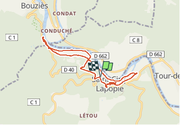
ST CIRQ LA POPIE

Papou63patrick
User

Length
8.9 km

Max alt
280 m

Uphill gradient
302 m
Km-Effort
13 km

Min alt
131 m

Downhill gradient
302 m
Boucle
Yes
Creation date :
2022-09-21 08:59:21.336
Updated on :
2022-09-21 13:37:37.514
2h37
Difficulty : Medium

FREE GPS app for hiking
 SityTrail
IGN / Geographical institutes
SityTrail Plus
The world is yours!
About
Trail Walking of 8.9 km to be discovered at Occitania, Lot, Saint-Cirq-Lapopie. This trail is proposed by Papou63patrick.
Photos


Positioning
Country:
France
Region :
Occitania
Department/Province :
Lot
Municipality :
Saint-Cirq-Lapopie
Location:
Unknown
Start:(Dec)
Start:(UTM)
393863 ; 4924544 (31T) N.
Comments