


Nemours SR200922 CRI180922 ve060522

fmg
User
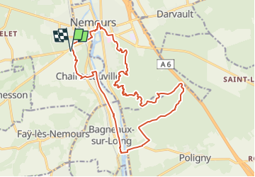

Length
19.9 km

Max alt
128 m

Uphill gradient
255 m
Km-Effort
23 km

Min alt
57 m

Downhill gradient
255 m
Boucle
Yes
Creation date :
2022-09-20 06:52:47.531
Updated on :
2022-09-21 17:09:07.561
5h12
Difficulty : Medium

FREE GPS app for hiking
 SityTrail
IGN / Geographical institutes
SityTrail Plus
The world is yours!
About
Trail Walking of 19.9 km to be discovered at Ile-de-France, Seine-et-Marne, Saint-Pierre-lès-Nemours. This trail is proposed by fmg.
Description
intéressant à l'époque de fleurissement des callunes et bruyères.
Positioning
Country:
France
Region :
Ile-de-France
Department/Province :
Seine-et-Marne
Municipality :
Saint-Pierre-lès-Nemours
Location:
Unknown
Start:(Dec)
Start:(UTM)
476586 ; 5345078 (31U) N.
Comments