


Amigny rouy

hm
User
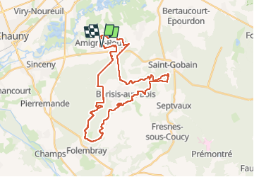

Length
34 km

Max alt
199 m

Uphill gradient
653 m
Km-Effort
43 km

Min alt
68 m

Downhill gradient
653 m
Boucle
Yes
Creation date :
2022-09-18 06:41:16.606
Updated on :
2022-09-22 03:25:57.412
3h17
Difficulty : Very difficult

FREE GPS app for hiking
 SityTrail
IGN / Geographical institutes
SityTrail Plus
The world is yours!
About
Trail Mountain bike of 34 km to be discovered at Hauts-de-France, Aisne, Amigny-Rouy. This trail is proposed by hm.
Description
magnifique !
Positioning
Country:
France
Region :
Hauts-de-France
Department/Province :
Aisne
Municipality :
Amigny-Rouy
Location:
Unknown
Start:(Dec)
Start:(UTM)
522160 ; 5495074 (31U) N.
Comments