


Landrethun le Nord APM

tenace
User
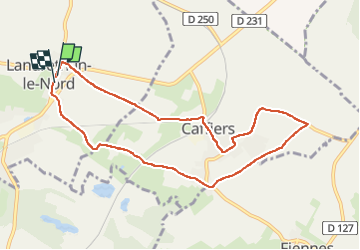

Length
8.3 km

Max alt
122 m

Uphill gradient
83 m
Km-Effort
9.4 km

Min alt
90 m

Downhill gradient
87 m
Boucle
Yes
Creation date :
2022-09-22 12:17:19.167
Updated on :
2022-09-22 14:17:12.739
1h44
Difficulty : Medium

FREE GPS app for hiking
 SityTrail
IGN / Geographical institutes
SityTrail Plus
The world is yours!
About
Trail Walking of 8.3 km to be discovered at Hauts-de-France, Pas-de-Calais, Landrethun-le-Nord. This trail is proposed by tenace.
Positioning
Country:
France
Region :
Hauts-de-France
Department/Province :
Pas-de-Calais
Municipality :
Landrethun-le-Nord
Location:
Unknown
Start:(Dec)
Start:(UTM)
414384 ; 5633508 (31U) N.
Comments