


les quatre lacs

aljac
User
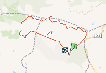

Length
10.8 km

Max alt
175 m

Uphill gradient
203 m
Km-Effort
13.5 km

Min alt
69 m

Downhill gradient
203 m
Boucle
Yes
Creation date :
2022-09-20 12:16:42.399
Updated on :
2022-09-23 07:51:59.92
2h54
Difficulty : Easy

FREE GPS app for hiking
 SityTrail
IGN / Geographical institutes
SityTrail Plus
The world is yours!
About
Trail Walking of 10.8 km to be discovered at Provence-Alpes-Côte d'Azur, Var, Puget-sur-Argens. This trail is proposed by aljac.
Positioning
Country:
France
Region :
Provence-Alpes-Côte d'Azur
Department/Province :
Var
Municipality :
Puget-sur-Argens
Location:
Unknown
Start:(Dec)
Start:(UTM)
313771 ; 4818753 (32T) N.
Comments