


mais forés michel

Yannick.Boireau
User
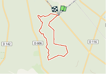

Length
7.4 km

Max alt
112 m

Uphill gradient
83 m
Km-Effort
8.5 km

Min alt
84 m

Downhill gradient
87 m
Boucle
Yes
Creation date :
2022-09-23 07:21:43.565
Updated on :
2022-09-23 09:47:50.048
2h01
Difficulty : Medium

FREE GPS app for hiking
 SityTrail
IGN / Geographical institutes
SityTrail Plus
The world is yours!
About
Trail Walking of 7.4 km to be discovered at Ile-de-France, Seine-et-Marne, Fontainebleau. This trail is proposed by Yannick.Boireau.
Positioning
Country:
France
Region :
Ile-de-France
Department/Province :
Seine-et-Marne
Municipality :
Fontainebleau
Location:
Unknown
Start:(Dec)
Start:(UTM)
477882 ; 5367278 (31U) N.
Comments