


Chantejals

boudpn
User
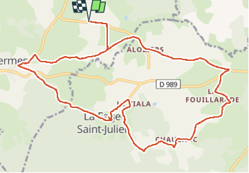

Length
14.4 km

Max alt
1138 m

Uphill gradient
266 m
Km-Effort
17.9 km

Min alt
1035 m

Downhill gradient
267 m
Boucle
Yes
Creation date :
2022-09-23 07:36:59.0
Updated on :
2022-09-23 13:24:59.5
5h47
Difficulty : Difficult

FREE GPS app for hiking
 SityTrail
IGN / Geographical institutes
SityTrail Plus
The world is yours!
About
Trail Walking of 14.4 km to be discovered at Occitania, Lozère, Termes. This trail is proposed by boudpn.
Description
Magnifique facile
Positioning
Country:
France
Region :
Occitania
Department/Province :
Lozère
Municipality :
Termes
Location:
Unknown
Start:(Dec)
Start:(UTM)
514758 ; 4962977 (31T) N.
Comments