


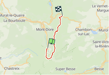
Sancy/col de La Croix Moran
© OpenStreetMap contributors


5h39
Difficulty : Very difficult


Length
14.6 km
Max alt
1832 m
Uphill gradient
1024 m
Km-Effort
28 km
Min alt
1295 m
Downhill gradient
922 m
Boucle
No
Creation date :
2022-09-23 06:47:24.0
Updated on :
2022-09-24 07:05:03.382
5h39
Difficulty : Very difficult
FREE GPS app for hiking
 SityTrail
IGN / Geographical institutes
SityTrail Plus
The world is yours!
About
Trail Walking of 14.6 km to be discovered at Auvergne-Rhône-Alpes, Puy-de-Dôme, Mont-Dore. This trail is proposed by 001684.da93e47b4c1543cdba58b05a314a4094.1618.
Positioning
Country:
France
Region :
Auvergne-Rhône-Alpes
Department/Province :
Puy-de-Dôme
Municipality :
Mont-Dore
Location:
Unknown
Start:(Dec)
Start:(UTM)
485666 ; 5043503 (31T) N.
Comments