


contres

lecmic
User
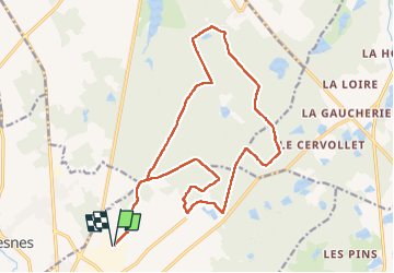

Length
19.7 km

Max alt
126 m

Uphill gradient
157 m
Km-Effort
22 km

Min alt
99 m

Downhill gradient
157 m
Boucle
Yes
Creation date :
2022-09-25 05:14:28.254
Updated on :
2022-09-25 08:45:04.13
3h23
Difficulty : Medium

FREE GPS app for hiking
 SityTrail
IGN / Geographical institutes
SityTrail Plus
The world is yours!
About
Trail Walking of 19.7 km to be discovered at Centre-Loire Valley, Loir-et-Cher, Le Controis-en-Sologne. This trail is proposed by lecmic.
Description
rando de la bernach
Positioning
Country:
France
Region :
Centre-Loire Valley
Department/Province :
Loir-et-Cher
Municipality :
Le Controis-en-Sologne
Location:
Unknown
Start:(Dec)
Start:(UTM)
382832 ; 5254529 (31T) N.
Comments