


Cimetière source de la rouge eau chantemelle les péri s. Après

iznogud
User
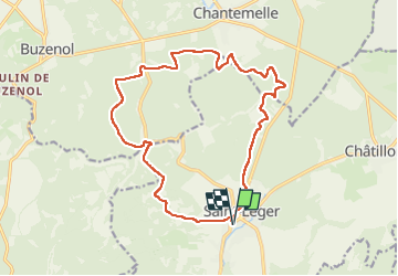

Length
16.1 km

Max alt
366 m

Uphill gradient
304 m
Km-Effort
20 km

Min alt
259 m

Downhill gradient
304 m
Boucle
Yes
Creation date :
2022-09-25 08:14:04.0
Updated on :
2022-09-25 10:45:30.619
2h30
Difficulty : Difficult

FREE GPS app for hiking
 SityTrail
IGN / Geographical institutes
SityTrail Plus
The world is yours!
About
Trail Trail of 16.1 km to be discovered at Wallonia, Luxembourg, Saint-Léger. This trail is proposed by iznogud.
Positioning
Country:
Belgium
Region :
Wallonia
Department/Province :
Luxembourg
Municipality :
Saint-Léger
Location:
Saint-Léger
Start:(Dec)
Start:(UTM)
691758 ; 5498750 (31U) N.
Comments