


RD-Viriville-Gallix&Mitifiot

raymondfn
User
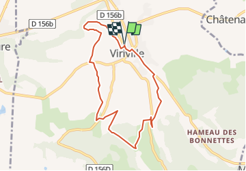

Length
8.5 km

Max alt
507 m

Uphill gradient
190 m
Km-Effort
11 km

Min alt
352 m

Downhill gradient
190 m
Boucle
Yes
Creation date :
2022-09-26 07:34:51.937
Updated on :
2022-09-26 07:49:30.511
2h11
Difficulty : Medium

FREE GPS app for hiking
 SityTrail
IGN / Geographical institutes
SityTrail Plus
The world is yours!
About
Trail Walking of 8.5 km to be discovered at Auvergne-Rhône-Alpes, Isère, Viriville. This trail is proposed by raymondfn.
Description
Parcours à vérifier
Positioning
Country:
France
Region :
Auvergne-Rhône-Alpes
Department/Province :
Isère
Municipality :
Viriville
Location:
Unknown
Start:(Dec)
Start:(UTM)
672645 ; 5020489 (31T) N.
Comments