


Luziers footing2

oliviergau
User
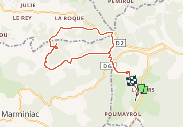

Length
9.4 km

Max alt
304 m

Uphill gradient
216 m
Km-Effort
12.3 km

Min alt
194 m

Downhill gradient
218 m
Boucle
No
Creation date :
2022-09-26 06:21:57.759
Updated on :
2022-09-26 07:51:21.005
1h28
Difficulty : Very easy

FREE GPS app for hiking
 SityTrail
IGN / Geographical institutes
SityTrail Plus
The world is yours!
About
Trail Running of 9.4 km to be discovered at Occitania, Lot, Salviac. This trail is proposed by oliviergau.
Positioning
Country:
France
Region :
Occitania
Department/Province :
Lot
Municipality :
Salviac
Location:
Unknown
Start:(Dec)
Start:(UTM)
359887 ; 4947717 (31T) N.
Comments