


Vals Thieure

pb07
User
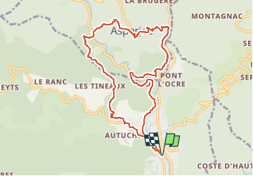

Length
11 km

Max alt
560 m

Uphill gradient
548 m
Km-Effort
18.3 km

Min alt
256 m

Downhill gradient
549 m
Boucle
Yes
Creation date :
2022-09-26 08:00:52.987
Updated on :
2022-09-26 13:25:03.67
4h39
Difficulty : Difficult

FREE GPS app for hiking
 SityTrail
IGN / Geographical institutes
SityTrail Plus
The world is yours!
About
Trail Walking of 11 km to be discovered at Auvergne-Rhône-Alpes, Ardèche, Vals-les-Bains. This trail is proposed by pb07.
Positioning
Country:
France
Region :
Auvergne-Rhône-Alpes
Department/Province :
Ardèche
Municipality :
Vals-les-Bains
Location:
Unknown
Start:(Dec)
Start:(UTM)
608289 ; 4946589 (31T) N.
Comments