


tour de la Pointe de Banc Plat

Mariolebeno
User
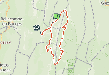

Length
16.9 km

Max alt
1878 m

Uphill gradient
954 m
Km-Effort
30 km

Min alt
1182 m

Downhill gradient
1091 m
Boucle
No
Creation date :
2022-09-26 15:15:47.816
Updated on :
2022-10-26 12:13:54.201
6h34
Difficulty : Very difficult

FREE GPS app for hiking
 SityTrail
IGN / Geographical institutes
SityTrail Plus
The world is yours!
About
Trail Walking of 16.9 km to be discovered at Auvergne-Rhône-Alpes, Upper Savoy, Doussard. This trail is proposed by Mariolebeno.
Positioning
Country:
France
Region :
Auvergne-Rhône-Alpes
Department/Province :
Upper Savoy
Municipality :
Doussard
Location:
Unknown
Start:(Dec)
Start:(UTM)
281226 ; 5068631 (32T) N.
Comments