


larmor baden

lm178
User
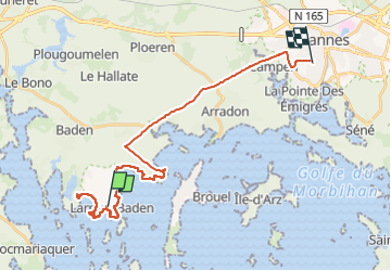

Length
29 km

Max alt
51 m

Uphill gradient
286 m
Km-Effort
33 km

Min alt
0 m

Downhill gradient
279 m
Boucle
No
Creation date :
2022-09-23 10:11:11.859
Updated on :
2022-09-26 16:57:38.411
4h24
Difficulty : Easy

FREE GPS app for hiking
 SityTrail
IGN / Geographical institutes
SityTrail Plus
The world is yours!
About
Trail Walking of 29 km to be discovered at Brittany, Morbihan, Larmor-Baden. This trail is proposed by lm178.
Positioning
Country:
France
Region :
Brittany
Department/Province :
Morbihan
Municipality :
Larmor-Baden
Location:
Unknown
Start:(Dec)
Start:(UTM)
507749 ; 5270439 (30T) N.
Comments