Trail Walking Puget - SityTrail - Les borries  - Photo
 MicDul
MicDul

User

© OpenStreetMap contributors
Length
Length
7.5 km
Max alt
Max alt
331 m
Uphill gradient
Uphill gradient
263 m
Km-Effort
Km-Effort  
11 km
Min alt
Min alt
142 m
Downhill gradient
Downhill gradient
263 m
Boucle
Boucle
Yes
Creation date :
2022-09-27 09:37:42.256
Updated on :
2022-09-28 13:04:24.287

(0 Reviews)

Walking
Walking
3h00
Difficulty : Medium

Scan this QR Code to open this trail in the SityTrail application

FREE GPS app for hiking

Logo SityTrail SityTrail

IGN / Geographical institutes

Download SityTrail from the App Store Download SityTrail from Google Play

Logo SityTrail SityTrail World

The world is yours!

Download SityTrail from the App Store Download SityTrail from Google Play Download SityTrail on Huawei AppGallery

About

Trail Walking of 7.5 km to be discovered at Provence-Alpes-Côte d'Azur, Vaucluse, Puget. This trail is proposed by MicDul.

Description

Pierriers aussi bien en montée qu'en descente.
Etre très prudent !

Elevation profile

Photos

Positioning

Country:
France
Region :
Provence-Alpes-Côte d'Azur
Department/Province :
Vaucluse
Municipality :
Puget
Location:
Unknown
Start:(UTM)
679987 ; 4847516 (31T) N.

Trails nearby

Trail Walking Bonnieux - Forêt de Cêdre - Roque des Bancs - Baume Rousse - Grottes de Font Scure et des Vaudois - Le Portalas  - Photo
Walking
tracegps

Walking

Medium
(5)
Bonnieux, Provence-Alpes-Côte d'Azur, Vaucluse, France
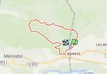
9.3 km | 14.2 km-effort
4h 0min
Yes
Trail On foot Bonnieux - Rando2 foret-des-cedres-bonnieux-2021 - Photo
On foot
ramille

On foot

Medium
(1)
Bonnieux, Provence-Alpes-Côte d'Azur, Vaucluse, France
14.8 km | 24 km-effort
5h 28min
Yes
Trail Walking Charleval - CHAINE DES COTES CHARLEVAL - Photo
Walking
ARPF

Walking

Medium
(1)
Charleval, Provence-Alpes-Côte d'Azur, Bouches-du-Rhône, France
12.6 km | 17.9 km-effort
3h 46min
Yes
Trail Walking Charleval - Gambadous - Charleval - Photo
Walking
Taricot

Walking

Easy
(2)
Charleval, Provence-Alpes-Côte d'Azur, Bouches-du-Rhône, France
7.5 km | 10.5 km-effort
2h 13min
Yes
Trail Walking Mérindol - Mérindol - Photo
Walking
titoune51

Walking

Medium
(1)
Mérindol, Provence-Alpes-Côte d'Azur, Vaucluse, France
7.2 km | 10.2 km-effort
2h 37min
Yes
Trail Walking Mallemort - SityTrail - GRvP - De Mallemort à Mérindol - Photo
Walking
MicDul

Walking

Easy
Mallemort, Provence-Alpes-Côte d'Azur, Bouches-du-Rhône, France
5.3 km | 6.1 km-effort
1h 30min
No
Trail Walking Charleval - Les hauts de Charleval 13 - Photo
Walking
Dadou 1

Walking

Very easy
Charleval, Provence-Alpes-Côte d'Azur, Bouches-du-Rhône, France
9.3 km | 12.3 km-effort
3h 17min
Yes
Trail Walking Mérindol - Les Borrys  Tête de la boutique  - Photo
Walking
Manoune

Walking

Easy
Mérindol, Provence-Alpes-Côte d'Azur, Vaucluse, France
13.4 km | 17.9 km-effort
4h 58min
Yes
Trail Walking Mérindol - Ruines de Mérindol - Photo
Walking
sereton

Walking

Easy
Mérindol, Provence-Alpes-Côte d'Azur, Vaucluse, France
8.6 km | 11.5 km-effort
2h 39min
Yes


Close
My subscriptions