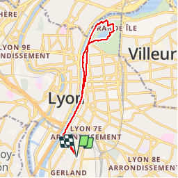
Lyon-Berges du Rhône Parc Tête d'Or

clrenaud
User

Length
13.9 km

Max alt
188 m

Uphill gradient
133 m
Km-Effort
15.6 km

Min alt
160 m

Downhill gradient
133 m
Boucle
Yes
Creation date :
2014-12-10 00:00:00.0
Updated on :
2014-12-10 00:00:00.0
3h26
Difficulty : Easy

FREE GPS app for hiking
 SityTrail
IGN / Geographical institutes
SityTrail Plus
The world is yours!
About
Trail Walking of 13.9 km to be discovered at Auvergne-Rhône-Alpes, Métropole de Lyon, Lyon. This trail is proposed by clrenaud.
Description
Départ métro J.Jaurès - Berges du Rhône et retour par le Parc Tête d'Or
Positioning
Country:
France
Region :
Auvergne-Rhône-Alpes
Department/Province :
Métropole de Lyon
Municipality :
Lyon
Location:
Lyon 7e Arrondissement
Start:(Dec)
Start:(UTM)
642951 ; 5066520 (31T) N.
Comments