


cougoir

andrechauvin
User
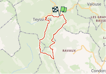

Length
14.3 km

Max alt
1203 m

Uphill gradient
789 m
Km-Effort
25 km

Min alt
614 m

Downhill gradient
792 m
Boucle
Yes
Creation date :
2022-09-27 07:04:19.573
Updated on :
2022-09-27 16:11:22.933
6h23
Difficulty : Difficult

FREE GPS app for hiking
 SityTrail
IGN / Geographical institutes
SityTrail Plus
The world is yours!
About
Trail Walking of 14.3 km to be discovered at Auvergne-Rhône-Alpes, Drôme, Teyssières. This trail is proposed by andrechauvin.
Description
belle balade
Positioning
Country:
France
Region :
Auvergne-Rhône-Alpes
Department/Province :
Drôme
Municipality :
Teyssières
Location:
Unknown
Start:(Dec)
Start:(UTM)
671265 ; 4924385 (31T) N.
Comments