


100 km de theillay

levequejef
User
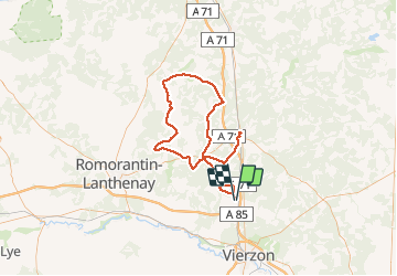

Length
101 km

Max alt
140 m

Uphill gradient
758 m
Km-Effort
111 km

Min alt
91 m

Downhill gradient
757 m
Boucle
No
Creation date :
2014-12-10 00:00:00.0
Updated on :
2014-12-10 00:00:00.0
12h00
Difficulty : Medium

FREE GPS app for hiking
 SityTrail
IGN / Geographical institutes
SityTrail Plus
The world is yours!
About
Trail Running of 101 km to be discovered at Centre-Loire Valley, Loir-et-Cher, Theillay. This trail is proposed by levequejef.
Positioning
Country:
France
Region :
Centre-Loire Valley
Department/Province :
Loir-et-Cher
Municipality :
Theillay
Location:
Unknown
Start:(Dec)
Start:(UTM)
427260 ; 5240602 (31T) N.
Comments