


2022-09-28_13h36m37__chedeville-9kmsgpxchedeville-9kms

Marc ROUSSELOT
User
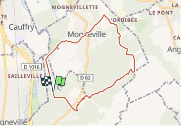

Length
8 km

Max alt
114 m

Uphill gradient
106 m
Km-Effort
9.5 km

Min alt
37 m

Downhill gradient
107 m
Boucle
Yes
Creation date :
2022-09-28 11:36:39.898
Updated on :
2022-09-28 11:36:41.734

FREE GPS app for hiking
 SityTrail
IGN / Geographical institutes
SityTrail Plus
The world is yours!
About
Trail of 8 km to be discovered at Hauts-de-France, Oise, Monchy-Saint-Éloi. This trail is proposed by Marc ROUSSELOT.
Description
Petite rando avant le Pique Nique
Départ parking du parc de Chédeville
Positioning
Country:
France
Region :
Hauts-de-France
Department/Province :
Oise
Municipality :
Monchy-Saint-Éloi
Location:
Unknown
Start:(Dec)
Start:(UTM)
460761 ; 5461200 (31U) N.
Comments