


Gorges du Destel-28-09-22

Christiancordin
User
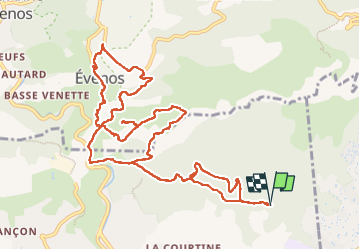

Length
14.8 km

Max alt
422 m

Uphill gradient
855 m
Km-Effort
26 km

Min alt
82 m

Downhill gradient
855 m
Boucle
Yes
Creation date :
2022-09-28 06:51:16.425
Updated on :
2022-10-16 17:37:26.322
4h50
Difficulty : Difficult

FREE GPS app for hiking
 SityTrail
IGN / Geographical institutes
SityTrail Plus
The world is yours!
About
Trail Walking of 14.8 km to be discovered at Provence-Alpes-Côte d'Azur, Var, Ollioules. This trail is proposed by Christiancordin.
Description
Départ Châteauvallon-four à chaux du Détras-Apié du Détras-col du Télégraphe- Télégraphe de Chappe-limite de commune-château du Diable-Evenos-Cuves du Destel.
Photos


Positioning
Country:
France
Region :
Provence-Alpes-Côte d'Azur
Department/Province :
Var
Municipality :
Ollioules
Location:
Unknown
Start:(Dec)
Start:(UTM)
733877 ; 4781165 (31T) N.
Comments