


St Anne Evenos - Tête du vicaire

soca
User
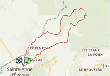

Length
9.8 km

Max alt
543 m

Uphill gradient
402 m
Km-Effort
15.1 km

Min alt
149 m

Downhill gradient
402 m
Boucle
Yes
Creation date :
2022-09-28 15:30:19.035
Updated on :
2022-09-28 15:30:32.511
3h30
Difficulty : Medium

FREE GPS app for hiking
 SityTrail
IGN / Geographical institutes
SityTrail Plus
The world is yours!
About
Trail Walking of 9.8 km to be discovered at Provence-Alpes-Côte d'Azur, Var, Évenos. This trail is proposed by soca.
Positioning
Country:
France
Region :
Provence-Alpes-Côte d'Azur
Department/Province :
Var
Municipality :
Évenos
Location:
Unknown
Start:(Dec)
Start:(UTM)
730187 ; 4784047 (31T) N.
Comments