


armsberg

BernardAF
User
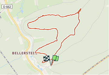

Length
5.6 km

Max alt
358 m

Uphill gradient
172 m
Km-Effort
7.9 km

Min alt
241 m

Downhill gradient
173 m
Boucle
Yes
Creation date :
2022-09-29 11:42:50.8
Updated on :
2022-09-29 14:18:40.549
2h35
Difficulty : Very easy

FREE GPS app for hiking
 SityTrail
IGN / Geographical institutes
SityTrail Plus
The world is yours!
About
Trail Walking of 5.6 km to be discovered at Grand Est, Moselle, Éguelshardt. This trail is proposed by BernardAF.
Description
cèpes
Positioning
Country:
France
Region :
Grand Est
Department/Province :
Moselle
Municipality :
Éguelshardt
Location:
Unknown
Start:(Dec)
Start:(UTM)
390601 ; 5429416 (32U) N.
Comments