


Font de l'Orme- St Phalez-Mérindol

Berpav
User
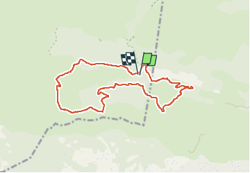

Length
9.2 km

Max alt
372 m

Uphill gradient
217 m
Km-Effort
12 km

Min alt
221 m

Downhill gradient
213 m
Boucle
Yes
Creation date :
2022-09-23 07:03:10.504
Updated on :
2022-10-07 08:45:04.393
2h14
Difficulty : Difficult

FREE GPS app for hiking
 SityTrail
IGN / Geographical institutes
SityTrail Plus
The world is yours!
About
Trail Walking of 9.2 km to be discovered at Provence-Alpes-Côte d'Azur, Vaucluse, Cheval-Blanc. This trail is proposed by Berpav.
Positioning
Country:
France
Region :
Provence-Alpes-Côte d'Azur
Department/Province :
Vaucluse
Municipality :
Cheval-Blanc
Location:
Unknown
Start:(Dec)
Start:(UTM)
676340 ; 4849135 (31T) N.
Comments