


vent des forêts

bohynm
User
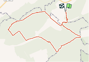

Length
12.8 km

Max alt
345 m

Uphill gradient
157 m
Km-Effort
14.9 km

Min alt
271 m

Downhill gradient
156 m
Boucle
Yes
Creation date :
2015-05-09 00:00:00.0
Updated on :
2015-05-09 00:00:00.0
2h49
Difficulty : Medium

FREE GPS app for hiking
 SityTrail
IGN / Geographical institutes
SityTrail Plus
The world is yours!
About
Trail Walking of 12.8 km to be discovered at Grand Est, Meuse, Lahaymeix. This trail is proposed by bohynm.
Photos


21 photos in total. Please click on a photo to see them all in the gallery.
Positioning
Country:
France
Region :
Grand Est
Department/Province :
Meuse
Municipality :
Lahaymeix
Location:
Unknown
Start:(Dec)
Start:(UTM)
675030 ; 5422165 (31U) N.
Comments