


St-Geoirs-Telethon2022-14km

raymondfn
User
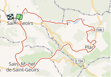

Length
13.9 km

Max alt
621 m

Uphill gradient
397 m
Km-Effort
19.2 km

Min alt
433 m

Downhill gradient
398 m
Boucle
Yes
Creation date :
2022-10-01 07:36:03.349
Updated on :
2022-10-20 15:43:22.399
5h29
Difficulty : Very difficult

FREE GPS app for hiking
 SityTrail
IGN / Geographical institutes
SityTrail Plus
The world is yours!
About
Trail Walking of 13.9 km to be discovered at Auvergne-Rhône-Alpes, Isère, Saint-Geoirs. This trail is proposed by raymondfn.
Positioning
Country:
France
Region :
Auvergne-Rhône-Alpes
Department/Province :
Isère
Municipality :
Saint-Geoirs
Location:
Unknown
Start:(Dec)
Start:(UTM)
684270 ; 5021393 (31T) N.
Comments