


reco labatie st agreve tence

ikusen26@gmail.com
User
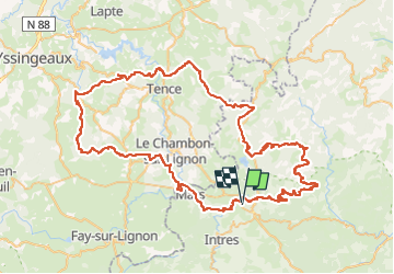

Length
98 km

Max alt
1310 m

Uphill gradient
3096 m
Km-Effort
139 km

Min alt
605 m

Downhill gradient
3089 m
Boucle
Yes
Creation date :
2022-10-02 07:39:05.151
Updated on :
2022-10-02 11:06:53.658
3h12
Difficulty : Very easy

FREE GPS app for hiking
 SityTrail
IGN / Geographical institutes
SityTrail Plus
The world is yours!
About
Trail Motorbike of 98 km to be discovered at Auvergne-Rhône-Alpes, Ardèche, Saint-Agrève. This trail is proposed by ikusen26@gmail.com.
Positioning
Country:
France
Region :
Auvergne-Rhône-Alpes
Department/Province :
Ardèche
Municipality :
Saint-Agrève
Location:
Unknown
Start:(Dec)
Start:(UTM)
609398 ; 4985341 (31T) N.
Comments