


brignais- Chaponost aqueduc romain

XavierFaidix
User
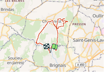

Length
15.6 km

Max alt
330 m

Uphill gradient
324 m
Km-Effort
20 km

Min alt
215 m

Downhill gradient
325 m
Boucle
Yes
Creation date :
2022-10-02 09:18:16.768
Updated on :
2022-10-02 14:49:05.958
4h30
Difficulty : Medium

FREE GPS app for hiking
 SityTrail
IGN / Geographical institutes
SityTrail Plus
The world is yours!
About
Trail Walking of 15.6 km to be discovered at Auvergne-Rhône-Alpes, Rhône, Brignais. This trail is proposed by XavierFaidix.
Description
éviter sur la fin de quitter le sentier de randonnée indiqué
Positioning
Country:
France
Region :
Auvergne-Rhône-Alpes
Department/Province :
Rhône
Municipality :
Brignais
Location:
Unknown
Start:(Dec)
Start:(UTM)
635941 ; 5060422 (31T) N.
Comments