


mandeure "rando pop"

bernardrampft
User
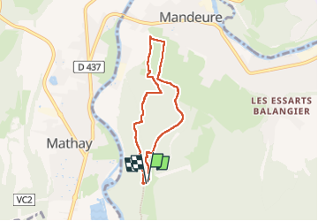

Length
6 km

Max alt
494 m

Uphill gradient
153 m
Km-Effort
8.1 km

Min alt
347 m

Downhill gradient
153 m
Boucle
Yes
Creation date :
2022-10-02 11:40:31.32
Updated on :
2022-10-04 15:08:37.928
3h01
Difficulty : Medium

FREE GPS app for hiking
 SityTrail
IGN / Geographical institutes
SityTrail Plus
The world is yours!
About
Trail Walking of 6 km to be discovered at Bourgogne-Franche-Comté, Doubs, Mandeure. This trail is proposed by bernardrampft.
Description
randonnée moyenne avec une grande descente puisla remontee
Positioning
Country:
France
Region :
Bourgogne-Franche-Comté
Department/Province :
Doubs
Municipality :
Mandeure
Location:
Unknown
Start:(Dec)
Start:(UTM)
333845 ; 5255339 (32T) N.
Comments