Trevignon

taguette
User
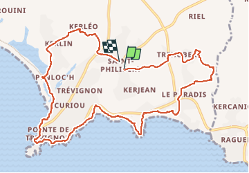

Length
12.1 km

Max alt
29 m

Uphill gradient
76 m
Km-Effort
13.1 km

Min alt
-1 m

Downhill gradient
82 m
Boucle
Yes
Creation date :
2022-10-04 11:06:32.701
Updated on :
2022-10-04 14:09:42.18
3h00
Difficulty : Easy

FREE GPS app for hiking
 SityTrail
IGN / Geographical institutes
SityTrail Plus
The world is yours!
About
Trail Walking of 12.1 km to be discovered at Brittany, Finistère, Trégunc. This trail is proposed by taguette.
Positioning
Country:
France
Region :
Brittany
Department/Province :
Finistère
Municipality :
Trégunc
Location:
Unknown
Start:(Dec)
Start:(UTM)
437701 ; 5294917 (30T) N.
Comments