


q3

aldaus
User
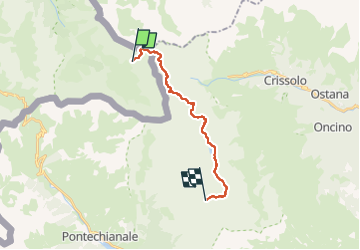

Length
16.8 km

Max alt
2966 m

Uphill gradient
1262 m
Km-Effort
33 km

Min alt
2296 m

Downhill gradient
1038 m
Boucle
No
Creation date :
2022-10-03 06:40:20.965
Updated on :
2022-10-04 15:21:00.991
7h27
Difficulty : Medium

FREE GPS app for hiking
 SityTrail
IGN / Geographical institutes
SityTrail Plus
The world is yours!
About
Trail Walking of 16.8 km to be discovered at Provence-Alpes-Côte d'Azur, Hautes-Alpes, Abriès-Ristolas. This trail is proposed by aldaus.
Positioning
Country:
France
Region :
Provence-Alpes-Côte d'Azur
Department/Province :
Hautes-Alpes
Municipality :
Abriès-Ristolas
Location:
Ristolas
Start:(Dec)
Start:(UTM)
345762 ; 4952375 (32T) N.
Comments