


Lac Blanc par refuge Jean Collet

GOHIER
User
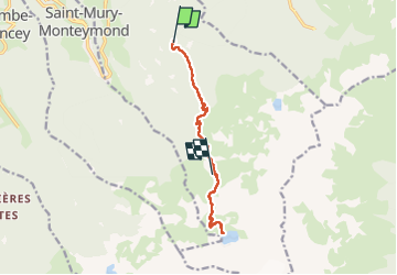

Length
10.5 km

Max alt
2185 m

Uphill gradient
1081 m
Km-Effort
23 km

Min alt
1304 m

Downhill gradient
443 m
Boucle
No
Creation date :
2022-10-04 08:57:56.0
Updated on :
2022-10-04 16:47:32.438
7h47
Difficulty : Medium

FREE GPS app for hiking
 SityTrail
IGN / Geographical institutes
SityTrail Plus
The world is yours!
About
Trail Walking of 10.5 km to be discovered at Auvergne-Rhône-Alpes, Isère, Sainte-Agnès. This trail is proposed by GOHIER.
Description
Magnifique vue sur le Grand Pic et nuit au refuge 🤗
Positioning
Country:
France
Region :
Auvergne-Rhône-Alpes
Department/Province :
Isère
Municipality :
Sainte-Agnès
Location:
Unknown
Start:(Dec)
Start:(UTM)
731992 ; 5011821 (31T) N.
Comments