


2022-10-05_11h28m02_montepilloy_sud_9x7km

Marc ROUSSELOT
User
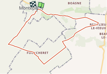

Length
9.7 km

Max alt
151 m

Uphill gradient
100 m
Km-Effort
11 km

Min alt
81 m

Downhill gradient
100 m
Boucle
Yes
Creation date :
2022-10-05 09:28:02.631
Updated on :
2022-10-05 09:28:05.5

FREE GPS app for hiking
 SityTrail
IGN / Geographical institutes
SityTrail Plus
The world is yours!
About
Trail of 9.7 km to be discovered at Hauts-de-France, Oise, Montépilloy. This trail is proposed by Marc ROUSSELOT.
Description
Départ du parking du cimetière.
Positioning
Country:
France
Region :
Hauts-de-France
Department/Province :
Oise
Municipality :
Montépilloy
Location:
Unknown
Start:(Dec)
Start:(UTM)
478141 ; 5450620 (31U) N.
Comments